Fájl:Coral Spot Fungus (Nectria cinnabarina) - geograph.org.uk - 1091903.jpg
Az előnézet mérete: 450 × 600 képpont További felbontások: 180 × 240 képpont | 480 × 640 képpont.
Eredeti fájl (480 × 640 képpont, fájlméret: 103 KB, MIME-típus: image/jpeg)
_-_geograph.org.uk_-_1091903.jpg)
Összefoglaló
| Leírás |
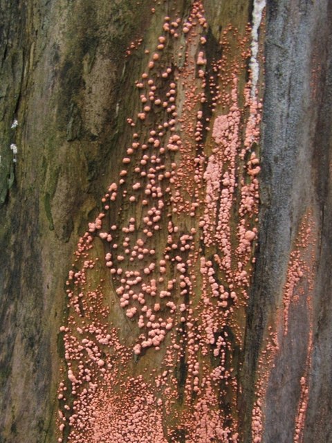
English: Coral Spot Fungus (Nectria cinnabarina). At the place where this picture was taken, there is a line of tree stumps on the pavement; the fungi shown here were growing on the side of one of them.
This dense covering of pustules is an example of the so-called "conidial stage" of the fungus Nectria cinnabarina; its coral-pink colour explains the common name of Coral Spot Fungus. This fungus occurs in dense groups on dead or dying wood - the twigs and branches of (usually) broad-leaved trees - and causes Coral-spot Disease; however, it is not a particularly strong parasite in itself, and its presence on a living plant probably indicates that its host was not in the best of condition to start with. Another commonly-encountered phase of its life-cycle, the so-called "perithecial stage", is shown on the right-hand side of the following photo: 1018737. As with many similar fungal species, it was not realized at first that the two phases were really the same species, and they were originally assigned different scientific names (in this case, the pink conidial stage was named Tuberculina vulgaris). When subsequent research reveals them to be merely two different stages of the same species, one of the two assigned names has to be discarded. |
| Dátum | |
| Forrás | From geograph.org.uk |
| Szerző | Lairich Rig |
| Így nevezd meg (a licenc megköveteli) | Lairich Rig / Coral Spot Fungus (Nectria cinnabarina) / |
_-_geograph.org.uk_-_1018737.jpg)
| Fényképező elhelyezkedése | | További képek erről a helyről: OpenStreetMap |
|---|
_-_geograph.org.uk_-_1091903.jpg¶ms=055.970410_N_-004.584900_E_globe:Earth_type:camera_source:geograph-osgb36(NS38777828)_heading:180.00&language=hu)
| Objektum elhelyezkedése | | További képek erről a helyről: OpenStreetMap |
|---|
_-_geograph.org.uk_-_1091903.jpg¶ms=055.970410_N_-004.584900_E_globe:Earth_class:object_type:object_source:geograph-osgb36(NS38777828)_heading:180.00&language=hu)
Licenc

|
This image was taken from the Geograph project collection. See this photograph's page on the Geograph website for the photographer's contact details. The copyright on this image is owned by Lairich Rig and is licensed for reuse under the Creative Commons Attribution-ShareAlike 2.0 license.
|
Ez a fájl a Creative Commons Nevezd meg! – Így add tovább! 2.0 Generic licenc alapján használható fel.
Így nevezd meg: Lairich Rig
- A következőket teheted a művel:
- megoszthatod – szabadon másolhatod, terjesztheted, bemutathatod és előadhatod a művet
- feldolgozhatod – származékos műveket hozhatsz létre
- Az alábbi feltételekkel:
- Nevezd meg! – A szerzőt megfelelően fel kell tüntetned, hivatkozást kell létrehoznod a licencre és jelezned kell, ha a művön változtatást hajtottál végre. Ezt bármilyen észszerű módon megteheted, kivéve oly módon, ami azt sugallná hogy a jogosult támogat téged vagy a felhasználásod körülményeit.
- Így add tovább! – Ha megváltoztatod, átalakítod, feldolgozod ezt a művet, a közreműködésedet csak az eredetivel megegyező vagy hasonló licenc alatt terjesztheted.
Fájltörténet
Kattints egy időpontra, hogy a fájl akkori állapotát láthasd.
| Dátum/idő | Bélyegkép | Felbontás | Feltöltő | Megjegyzés | |
|---|---|---|---|---|---|
| aktuális | 2011. február 24., 15:51 | | 480 × 640 (103 KB) | GeographBot | == {{int:filedesc}} == {{Information |description={{en|1=Coral Spot Fungus (Nectria cinnabarina) At the place where this picture was taken, there is a line of tree stumps on the pavement; the fungi shown here were growing on the side of one of them. Th |
Fájlhasználat
Az alábbi lapok használják ezt a fájlt:
Globális fájlhasználat
A következő wikik használják ezt a fájlt:
- Használata itt: ceb.wikipedia.org
_-_geograph.org.uk_-_1091903.jpg)