Fájl:Gelre1477.png
Az előnézet mérete: 688 × 600 képpont További felbontások: 275 × 240 képpont | 551 × 480 képpont | 772 × 673 képpont.
Eredeti fájl (772 × 673 képpont, fájlméret: 937 KB, MIME-típus: image/png)
Összefoglaló
| Leírás |
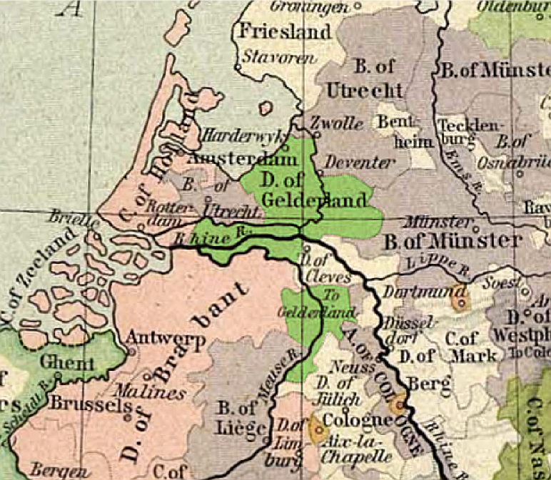
Français : Carte du duché de Gueldre, en 1477
English: Map of duchy of Guelders, in 1477 |
| Dátum | |
| Forrás | from Historical Atlas by William R. Shepherd, 1926. |
| Szerző | original map: de:Velhagen & Klasing |
Licenc
A szerző halálozási ideje 1934, ezért ez a mű közkincs abban az országban, ahol elkészítették, és minden olyan további államban, ahol a szerzői jogi védelmi idő a szerző élete plusz 80 év vagy kevesebb. | |
| Megállapították, hogy ez a fájl mentes mindenféle szerzői jogi korlátozástól, beleértve az összes kapcsolódó és hozzátartozó jogot. | |
This work is in the public domain because it was published in the United States between 1929 and 1963, and although there may or may not have been a copyright notice, the copyright was not renewed. For further explanation, see Commons:Hirtle chart and the copyright renewal logs. Note that it may still be copyrighted in jurisdictions that do not apply the rule of the shorter term for US works (depending on the date of the author's death), such as Canada (70 years p.m.a.), Mainland China (50 years p.m.a., not Hong Kong or Macao), Germany (70 years p.m.a.), Mexico (100 years p.m.a.), Switzerland (70 years p.m.a.), and other countries with individual treaties.
|
 |
Eredeti feltöltési napló
- uploadé sur Wikipédia NL par User:Känsterle le 17 décembre 2005.
- Highlighting of Guelders: User:Eugene van der Pijll.
Fájltörténet
Kattints egy időpontra, hogy a fájl akkori állapotát láthasd.
| Dátum/idő | Bélyegkép | Felbontás | Feltöltő | Megjegyzés | |
|---|---|---|---|---|---|
| aktuális | 2011. május 13., 22:13 | | 772 × 673 (937 KB) | Hans Erren | corrected southern boundary to include ambt montfort. Reloaded original perry castaneda map, Rotated to true north, adjusted gamma, sharpened, fill coloured area in more pastel tone. |
| 2006. február 25., 21:02 |  | 334 × 277 (183 KB) | Eugene van der Pijll | ||
| 2006. február 25., 20:20 |  | 334 × 277 (165 KB) | Odejea | == Description == Carte du duché de Gueldre, en 1477 Origine : * collection de cartes de l'Université du Texas (http://www.lib.utexas.edu/maps/). Ces cartes sont dans le domaine public (http://www.lib.utexas.edu/maps/faq.html#3.html). * uploadé sur W |
Fájlhasználat
Az alábbi lap használja ezt a fájlt:
Globális fájlhasználat
A következő wikik használják ezt a fájlt:
- Használata itt: af.wikipedia.org
- Használata itt: ar.wikipedia.org
- Használata itt: br.wikipedia.org
- Használata itt: ca.wikipedia.org
- Használata itt: da.wikipedia.org
- Használata itt: de.wikipedia.org
- Használata itt: en.wikipedia.org
- Használata itt: et.wikipedia.org
- Használata itt: fr.wikipedia.org
- Használata itt: he.wikipedia.org
- Használata itt: it.wikipedia.org
- Használata itt: li.wikipedia.org
- Használata itt: nds-nl.wikipedia.org
- Használata itt: nl.wikipedia.org
- Használata itt: nn.wikipedia.org
- Használata itt: no.wikipedia.org
- Használata itt: pl.wikipedia.org
- Használata itt: pt.wikipedia.org
- Használata itt: ru.wikipedia.org
- Használata itt: th.wikipedia.org